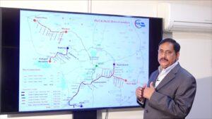
Telangana Chief Minister Sri A. Revanth Reddy reviewed the progress of Metro Rail phase two DPRs (Detailed Project Reports) preparation with senior officers of the MA&UD department on September 29th, 2024. Hyderabad Airport Metro Limited (HAML) MD NVS Reddy made a detailed presentation, explaining the alignment, salient features, station locations etc., of the metro second phase corridors.
Principal Secretary, MA&UD Mr M. Danakishore, CM’s Special Secretary Mr B. Ajit Reddy, HMDA Commissioner Mr Sarfraz Ahmad, GHMC Commissioner Ms Amrapali Kata and other senior officers participated in the discussion.
The MD informed the CM that DPRs for all the corridors are being given final touches and that HAML is awaiting the traffic study report of the Comprehensive Mobility Plan (CMP) being prepared for the Hyderabad Metropolitan Area by HMDA. The traffic projections for Metro corridors have to be cross-checked with CMP, as a mandatory requirement for submission of DPRs for Government of India approvals. He also mentioned that as decided in an earlier review meeting held by the CM, the Airport Metro alignment is now being finalized via Aramghar and the New High Court location on National Highway 44 (Bengaluru Highway) to reach Shamshabad Airport.
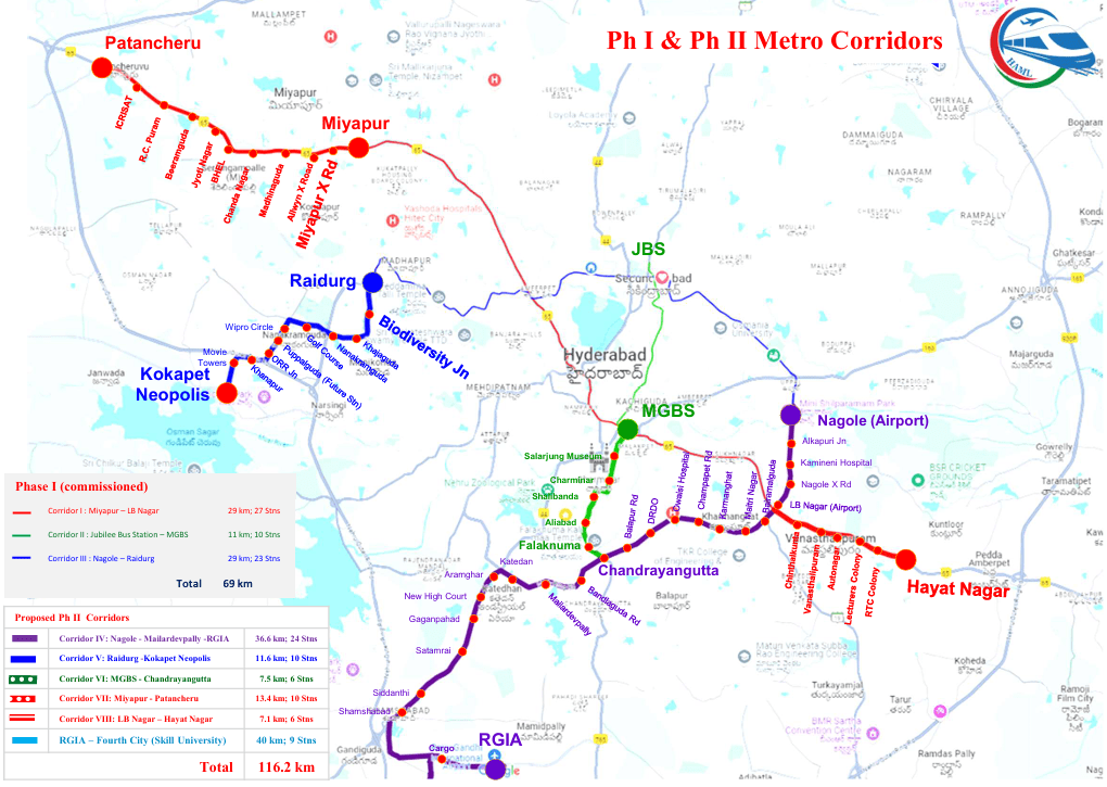
After in-depth discussions of the pros & cons of different alternatives, the CM approved the broad contours of Metro Phase II corridors as under:
- Corridor IV: Nagole – RGIA (Airport Corridor)
- Corridor V: Raidurg – Kokapet Neopolis
- Corridor VI: MGBS – Chandrayangutta (Old City Corridor)
- Corridor VII: Miyapur – Patancheru
- Corridor VIII: LB Nagar – Hayat Nagar
- Corridor IX: RGIA – Fourth City (Skill University)
- Total 116.2 km
- The Corridor IV (Airport Metro Corridor) covers a length of about 36.6 Km from Nagole to Shamshabad Airport via L.B Nagar, Karmanghat, Owaisi Hospital, DRDO, Chandrayangutta, Mailardevpally, Aramghar, New High Court and Shamshabad Jn on NH. This Airport line will be connected to all the existing Metro lines at Nagole, L.B Nagar and Chandrayangutta respectively. Out of the total length of 36.6 Km, 35 Km is elevated and 1.6 Km is underground, with 24 metro stations including one underground station which is the Airport station.
- The Corridor V is being built as an extension of Blue Line from Raidurg Metro station to Kokapet Neopolis via Biodiversity Jn, Khajaguda Rd, Nanakramguda Jn, Wipro Circle, Financial dist and Kokapet Neopolis. This is a wholly elevated corridor with about 8 stations.
- The Corridor VI (Old City Metro) is being built as an extension of the Green Line from MGBS to Chandrayangutta. This 7.5 km line from MGBS travels via Mandi Rd in Old City over Darulshifa Jn, Shalibanda Jn, and Falaknuma. Though the corridor is 500 mts away from Salarjung Museum and Charminar, these names are retained as the station names due to their historical significance. The road which is currently 60 ft between Darulshifa Jn to Shalibanda Jn; and 80 ft from Shalibanda Jn to Chandrayangutta is being widened to 100 ft uniformly. At the station locations, the road is being widened to 120 ft. About 1100 properties are getting affected in the road widening and for Metro alignment. Notifications have been already issued for 400 affected properties and the rest are in progress. There are about 103 religious, heritage and other sensitive structures in this route and all of them are being saved through appropriate engineering solutions and adjustment of Metro pillar locations. This is a wholly elevated metro corridor with about 6 stations.
- The Corridor VII is being built as an extension of the Red Line on the Mumbai highway. Starting from the existing Miyapur metro station, this 13.4 km line up to Patancheru travels via Alwyn X Rd, Madinaguda, Chanda Nagar, BHEL and ICRISAT. This is a wholly elevated corridor with about 10 stations.
- The Corridor VIII is being built as an extension of the Red Line from L.B Nagar side on the Vijayawada highway. This 7.1 km corridor from L.B Nagar to Hayat Nagar goes over Chintalkunta, Vanasthalipuram, Auto Nagar and RTC Colony. This wholly elevated corridor will have about 6 stations.
The DPRs for all these corridors will be finalized in the next few weeks for the approval of State government and Govt of India approval. Further, as instructed by the Chief Minister, metro connectivity is also being planned from Airport to the Fourth City via Mansanpally Rd, and the ORR stretch between Pedda Golconda exit and Raviryal exit. This line will have a length of about 40 km from Shamshabad Airport to the Skill University location in Fourth City. This will have about 2 km of underground portion within the Airport area; elevated portion of about 20 km; and ‘At Grade’ (road level) portion of about 18 km. The ‘At Grade’ portion of 18 km from ORR Raviryal exit to Skill University will be designed as a part of the new green field 300 ft road.
As per the special emphasis being laid by CM, the DPR is being prepared for the Fourth City Metro connectivity line in an innovative way with several attractive features and will be submitted for Govt of India approvals separately after a few months. The entire phase II project is expected to cost about Rs. 32,237 Cr including about Rs.8,000 Cr for the Fourth City Metro connectivity (Rs. 24,237 Cr + Rs. 8,000 Cr). The project is proposed to be implemented as a joint venture project of Govt of Telangana and Govt of India like most other Metro Rail projects in other Indian cities.